15M+
Acres Mapped under SVAMITVA
500+
Fleet of Survey Mapping Drones
200+
Fleet of Specialized Service Vans
100+
Projects Executed Successfully
10+
Options of Platforms & Payloads
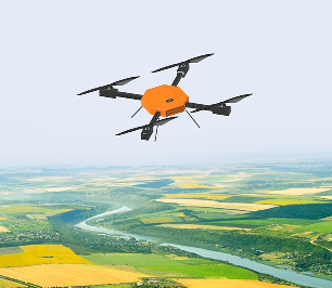
Drone Destination has built its survey and mapping capabilities on years of real field experience, from digitising land records for lakhs of villages under PM Svamitva Yojana to mapping over 10 lakh hectares across multiple Indian states. Our teams don't just fly drones, they understand the ground beneath them.
.png%3F2026-04-06T07%253A27%253A25.968Z&w=3840&q=100)
Chirag Sharma
CEO & MD, Drone Destination Ltd.
Deliverables Offered
Orthomosaic
TIF, TIFF, JPG, JP2
.png%3F2026-04-06T07%253A32%253A45.777Z&w=3840&q=100)
Digital Surface Model DSM
TIF, IMG, ASC
.png%3F2026-04-06T07%253A33%253A15.505Z&w=3840&q=100)
Digital Terrain Model DTM
TIF, IMG, ASC
.png%3F2026-04-06T07%253A33%253A44.045Z&w=3840&q=100)
Digital Elevation Model DEM
TIF, IMG, HGT
.png%3F2026-04-06T07%253A34%253A15.509Z&w=3840&q=100)
3D Point Cloud
LAS, LAZ, PLY
.png%3F2026-04-06T07%253A34%253A40.717Z&w=3840&q=100)
3D Textured Mesh
OBJ, FBX, DAE
.png%3F2026-04-06T07%253A35%253A04.385Z&w=3840&q=100)
Multispectral Indices
NDVI, NDRE, SAVI, TIF, IMG
.png%3F2026-04-06T07%253A35%253A28.930Z&w=3840&q=100)
SOLUTIONS
Comprehensive Survey & Mapping Solutions
Topographical 2D Survey Mapping
Generating accurate, high-resolution base maps for planning, development, and geospatial reference.
.png%3F2026-04-06T08%253A51%253A26.467Z&w=3840&q=100)
Benefits of choosing Drone Destination
Drone Destination's survey and mapping teams have delivered on some of India's most demanding projects, backed by DGCA-certified pilots, in-house GIS processing, and a pan-India operational presence.

Field-Proven Experience
From PM Svamitva Yojana to large-scale infrastructure mapping, our teams have delivered on India's most demanding survey projects across challenging terrains.
%25201.png%3F2026-04-06T09%253A42%253A53.512Z&w=3840&q=100)
DGCA-Certified Operation
Every survey mission is executed by licensed drone pilots operating within India's regulatory framework, ensuring compliance, safety, and data integrity on every project.

End-to-End Delivery
Every survey mission is executed by licensed drone pilots operating within India's regulatory framework, ensuring compliance, safety, & data integrity on every project.

Pan-India Presence
With operational teams across multiple states, we deploy quickly & efficiently, reducing mobilization time and keeping your project timelines on track.

Scalable for Any Project Size
Whether it's a 50-acre land parcel or a 10,000-hectare government survey, our operations scale to match your project scope without compromising on accuracy.
Applicable Industries


.png%3F2026-04-06T09%253A51%253A45.586Z&w=3840&q=100)
.png%3F2026-04-06T09%253A52%253A18.049Z&w=3840&q=100)
.png%3F2026-04-06T09%253A52%253A30.597Z&w=3840&q=100)
.png%3F2026-04-06T09%253A52%253A42.790Z&w=3840&q=100)
.png%3F2026-04-06T09%253A52%253A55.309Z&w=3840&q=100)
.png%3F2026-04-06T09%253A53%253A17.897Z&w=3840&q=100)
.png%3F2026-04-06T09%253A53%253A29.483Z&w=3840&q=100)
.png%3F2026-04-06T09%253A53%253A41.052Z&w=3840&q=100)
FAQs
What types of assets and infrastructure can Drone Destination inspect using drones?
What types of assets and infrastructure can Drone Destination inspect using drones?
What types of assets and infrastructure can Drone Destination inspect using drones?
What types of assets and infrastructure can Drone Destination inspect using drones?
What types of assets and infrastructure can Drone Destination inspect using drones?
Trusted by Professionals at
%25201.png%3F2026-04-06T10%253A03%253A19.640Z&w=3840&q=100)
%25203.png%3F2026-04-06T10%253A03%253A31.364Z&w=3840&q=100)
%25204.png%3F2026-04-06T10%253A03%253A44.241Z&w=3840&q=100)
%25205.png%3F2026-04-06T10%253A03%253A55.225Z&w=3840&q=100)
%25206.png%3F2026-04-06T10%253A04%253A07.009Z&w=3840&q=100)
%25207.png%3F2026-04-06T10%253A04%253A18.667Z&w=3840&q=100)
%25209.png%3F2026-04-06T10%253A04%253A43.928Z&w=3840&q=100)
See what people are talking! ❤️
As a professional in an MNC, I choose Drone Destiantion for DGCA-certified drone training- and it was outstanding. The team was professional and responsive from the start. Classroom sessions were clear and current, and the hands-on practical training was enough with advanced equipment. Instructors were supportive and highly skilled, and the guest house stay was smooth and comfortable. I’d rate the experience 9.5/10-highly recommended for working professionals and tech enthusiasts.

Hitesh Kumar
DGCA certified Pilot Training
Your Next Inspection Project Deserves the Professionals!
From power lines to industrial plants, our DGCA-certified inspection teams deliver accurate, safe, and cost-effective drone inspection solutions tailored to your project needs.

SOCIAL